Start with the question you have
| Your task | Start here | What you get |
|---|---|---|
| Find a possible facility | Map or directory | 1,650 licensed source rows with provenance, reported status and location precision. These are discovery leads, not a verified national total. |
| Check a project or facility | Reviewed records or search | Narrower records with a stable ID, defined record unit, evidence status, sources and dates. |
| Check a statement or question | Evidence & answers or public statements | A bounded finding, its evidence, remaining uncertainty and correction history. |
| Understand a rule or government action | Policy tracker | One row per sourced legal or administrative action. Policy rows are not facility counts and do not label a state “open” or “closed.” |
| Analyze or reuse records | Data downloads | Static JSON, selected CSV files, rights boundaries and source provenance from the same release that built the public pages. |
A project or campus may contain several buildings, tenants or provider presences. The reviewed project/campus inventory, reviewed facility/building inventory and licensed directory are separate, overlapping populations. Their counts are never added into one national facility total.
What one row means
| Record unit | Meaning | Do not assume |
|---|---|---|
| Project | A development proposal or undertaking documented in public records. | That it was approved, built or operates today. |
| Campus | A named site that may contain several phases or buildings. | That every announced phase exists or that one campus equals one building. |
| Building or operating facility | A physical data-center structure or operating site supported at that level. | That every tenant, suite or provider presence is a separate building. |
| Provider presence | A company reports service or space at a site. | That the provider owns or operates the building. |
| Licensed discovery row | A third-party source row preserved with its upstream ID, attribution and DataCenterData directory ID. | That DataCenterData independently verified its identity, status, capacity or coordinates. |
| Policy action | A sourced law, rule, order, tariff, pause, incentive, study or other government or grid action. | That it applies to every project, is permanent, or describes a facility. |
| Claim or public statement | A specific proposition reviewed against cited evidence. | That documenting the statement proves it true. |
Read the evidence label before the headline
- Reviewed or verified record: the cited evidence and record unit passed the publication checks. It remains dated and can be corrected.
- Attributed: a named source supports the attribution, but DataCenterData has not established the full fact independently.
- Unresolved: the lead is retained because it may matter, but its identity or relationship has not been settled.
- Licensed source row: the source supplied the row. DataCenterData preserves and organizes it under the disclosed license; it is not a DataCenterData finding.
- Company claim: the company said it. The label does not adopt the proposition as fact.
- Unknown: the reviewed sources do not establish the answer. Unknown is not zero, absent or false.
See every evidence-result definition →
Location and map precision
| Label | How to read it |
|---|---|
| Exact (provider label) | The upstream provider labeled the coordinates exact. DataCenterData has not converted that label into a parcel finding. |
| Approximate | The point is suitable for regional or local navigation, not a property boundary. This includes source points whose own notes describe only a city, ZIP code, metro or area. |
| Approximate (Census address interpolation) | The source publishes a street address but no coordinate. The point is the U.S. Census Bureau geocoder’s address-range interpolation of that published street, admitted only after DataCenterData checked the house number, street name, state, city or postal code and the state outline. It is a place to draw one listing, not a rooftop, parcel or building coordinate, and never proof that the listing is a distinct or operating facility. |
| Representative | The point represents the named place or record for display and should not be read as the facility entrance or parcel. |
| Shown through an attached licensed row | An operator’s own listing or a government record published on a licensed row’s page shares that row’s marker instead of receiving a second one. The list says so; the shared marker is not a same-site finding. |
| Bounded nearby group | Nearby source points are combined into one accessible map target. The original rows remain available from the linked result. |
A marker shows where a source places a row; it does not prove ownership, parcel boundaries, operating status or capacity. Use the row’s source citations for those questions.
Status, dates and capacity
- Source-reported status reproduces the directory provider’s lifecycle label. It is not independently verified unless a separate reviewed record says so.
- Status as of is the date supported by the cited evidence. A later page-access date does not silently make an older status current.
- Capacity is shown only with its stated boundary. Campus power, utility demand, contracted load, design capacity and critical IT load are not interchangeable.
- Not stated and unknown are not zero. Missing figures stay out of totals that require comparable values.
Downloads and reuse
The data page lists the public JSON and CSV files, their scope and reuse boundary. The licensed directory snapshot travels with its source manifest and stable-ID ledger. The national map SVG is available for reports with the attribution and limitations printed on the map page.
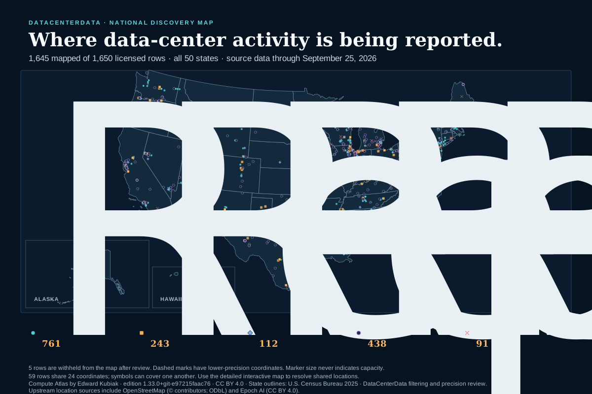
Linked permits, orders, filings, company pages and other source documents keep their own rights. A public URL is not, by itself, permission to republish the underlying document or database.
Report a missing facility or stronger evidence
Use the correction and missing-record form. For a missing facility or project, include the state and locality, the name used by the source, its reported status, and at least one public primary-source URL. An official permit, utility or commission filing, tax or incentive record, government page, or operator document is most useful.
A submission enters review; it does not publish automatically. DataCenterData first checks identity, record unit, dates, source rights and possible duplicates. Accepted factual changes appear in the public correction and change history.
Send one public source that identifies the place and one that supports the current status. If the source gives only a city or area, say that—the record can preserve an approximate location without inventing a parcel.